Investigate how GRACE-FO maps Earth’s gravity by measuring tiny distance changes between twin satellites, and experiment with varying mass distributions to observe gravity-induced variations using our interactive simulator.
Gravity Recovery and Climate Experiment – Follow-On (GRACE-FO)
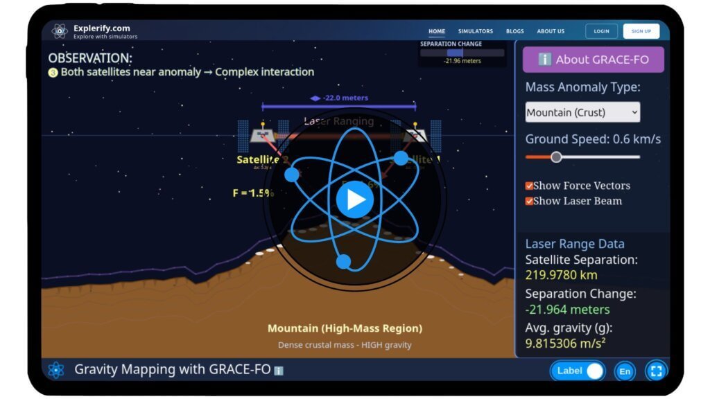
People argue about whether Earth is round or flat — but gravity tells us it’s actually a lumpy, uneven rock. And the GRACE-FO satellites are the ones exposing its true shape. By measuring tiny changes in the distance between two orbiting satellites, GRACE-FO reveals how mountains, ice, and underground water tug on Earth’s gravity. With our interactive simulator, you can recreate this yourself: move a mountain, shift mass, and watch the gravity signal change in real time.
GRACE-FO measures how differently the two satellites accelerate because of gravity variations below them. This difference in acceleration causes tiny changes in their spacing, which the satellite measures.
\( F = G \frac{M m}{r^2} \)
where:
\( F \) is the gravitational force between two objects.
\( G \) is the universal gravitational constant.
\( M \) is the mass of the first object.
\( m \) is the mass of the second object.
\( r \) is the distance between the centers of the two objects.
Simulator
Dive into the physics of Earth’s gravity variations with our interactive GRACE-FO simulator!
Share with your friends
FAQs on GRACE-FO
Qus 1. What is GRACE-FO?
GRACE-FO stands for Gravity Recovery and Climate Experiment – Follow-On. It’s a pair of satellites that measure tiny changes in Earth’s gravitational field.
Qus 2. Why does GRACE-FO use two satellites instead of one?
Two satellites flying in formation can measure tiny changes in the distance between them. These distance changes reveal variations in Earth’s gravity below.
Qus 3. How does GRACE-FO detect gravity changes?
When the satellites pass over regions with slightly stronger gravity, the lead satellite speeds up a bit. The trailing one follows later. GRACE-FO measures this tiny spacing change using a laser ranging interferometer.
Qus 4. Why does gravity vary on Earth?
Gravity changes due to movement of mass — things like mountains, oceans, groundwater, ice sheets, and even seasonal rainfall.
Qus 5. What can GRACE-FO data tell us about Earth?
It helps scientists track:
Melting ice sheets
Changes in groundwater
Sea level rise
Earthquake-related mass shifts
Long-term climate trends
Qus 6. How sensitive is GRACE-FO?
GRACE-FO can detect changes in distance smaller than the width of a human hair — around nanometers!
Qus 7. What is the role of the laser ranging interferometer?
It’s an ultra-precise laser system that measures the distance between the two satellites and improves accuracy compared to the original GRACE mission.
Qus 8. How often does GRACE-FO map Earth’s gravity?
Approximately every 30 days, GRACE-FO generates a new global gravity map.
Qus 9. Why does the Earth look “lumpy” in gravity maps?
Gravity maps show where mass is unevenly distributed. High gravity areas look like “bulges,” and low gravity areas look like “dips.” It’s not the shape of Earth’s surface — it’s the shape of its gravitational field.
Qus 10.What makes GRACE-FO important for climate science?
It tracks water movement around the planet, making it a powerful tool for monitoring climate-driven changes like glacier melt and groundwater depletion.